Table Of Contents

Latest update [menu]
The complete list is available in the changelog inside the application.
3.15b
• Added ability to backup and restore all the application data into or from a single file;
3.15a
• Added ability to display arrows, distances and ETE along the real-time location and compass heading lines;
• Added duration estimation of drawn paths and routes based on the selected activity, with time estimations of each route legs displayed on the map;
• And more
Description [menu]
No advertisements ~ No data sharing & monetization ~ No analytics ~ No third party libraries
Bored to wait for maps to display? Use All-In-One OfflineMaps! Once displayed, maps are stored and remain available, quickly, even with no network access.
• Want more than just roads on your maps? You will find what you need here;
• Used to go to places with poor network coverage? Everything will stay available;
• Used to go abroad? You won’t be lost anymore;
• Have a data allowance limit? It will reduce your usage.
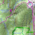
★★ Maps ★★
A lot of maps are available, including classical road maps, topographic maps, aerial (satellite) maps and various layers that can be added over any maps: OpenStreetMap (Roads, Topo), USGS National Map (Hi-res topo, Aerial imagery), Worldwide Military Soviet topo maps, etc.
• All maps can be stacked in layers, with precise opacity control;
• Select and store large areas in few clicks;
• Stored space is clear and can be easily deleted.
★★ Display, store and retrieve unlimited placemarks ★★
You can add various items on the map such as waypoints, icons, routes, areas and tracks.
You can easily manage them using the powerful SD-Card Placemarks Explorer.
★★ On-map GPS Location & Orientation ★★
Your real location and direction are clearly displayed on the map, which can be rotated to match your real orientation (depends on device capabilities).
Easy turn on/off to save battery.
And also:
• Metric, imperial and hybrid distance units;
• GPS Latitude/Longitude and grid coordinate formats (UTM, MGRS, USNG, OSGB Grid, Irish Grid, Swiss Grid, Lambert Grids, DFCI Grid, QTH Maidenhead Locator System, …);
• Ability to import hundreds of coordinate formats from https://www.spatialreference.org;
• On-map grids display;
• Full screen map view;
• Multi-touch zoom;
• …
★★ Need more? ★★
If you are a real adventurer, try AlpineQuest Off-Road Explorer, the complete outdoor solution based on All-In-One OfflineMaps, loaded with a powerful GPS Track Recorder and more: https://www.alpinequest.net/google-play
How to install All-In-One Offline Maps APK for Android [menu]
Download All-In-One Offline Maps APK file (net.psyberia.offlinemaps_135_7425082.apk) from SameAPK.com, then follow these steps:
Update Phone Settings
- Go to your phone Settings page
- Tap Security or Applications (varies with device)
- Check the Unknown Sources box
- Confirm with OK
Go to Downloads
- Open Downloads on your device by going to My Files or Files
- Tap the APK file you downloaded (net.psyberia.offlinemaps_135_7425082.apk)
- Tap Install when prompted, the APK file you downloaded will be installed on your device.
How to install All-In-One Offline Maps APK on Windows 7/8/10 or MAC PC? [menu]
Download All-In-One Offline Maps APK file(net.psyberia.offlinemaps_135_7425082.apk) from SameAPK.com to your PC (ex: /Users/xxx/Downloads/(net.psyberia.offlinemaps_135_7425082.apk)), then follow these steps:
Using Emulator:
- Download And Install one Emulator Softwares (Ex: Bluestacks, GenyMotion, NoxPlayer)
- Simple install APK on PC by drag and drop file net.psyberia.offlinemaps_135_7425082.apk on Emulator screen
All-In-One Offline Maps APK Pros & Cons [menu]
Pros
- This app is safe, it's not require high risk permissions
- Compatible with 32 bit device (most Emulator using 32bit arch CPU)
- Compatible with 64-bit device (some android device and current Bluestacks)
Cons
Everything is good.