
Table Of Contents

Latest update [menu]
Add functionality to migrate to consolidated app.
This app will be removed from the Play Store on January 1, 2022.
Description [menu]
Please download "FarOut" (formerly Guthook Guides) to access the John Muir Trail guide. Existing customers may transfer their purchases to the FarOut app.
Guthook's John Muir Trail Guide is a smartphone guide for your hike on the John Muir Trail. It covers the 210.5 mile John Muir Trail from Happy Isles in Yosemite National Park to the summit of Mt. Whitney. It also includes the entire Mt. Whitney Trail (10.4 mile trail from Whitney Portal to Mt. Whitney summit) and many side trails.
Key features:
- No mobile or internet connection is required after initial setup -- works in Airplane Mode
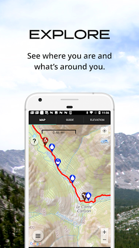
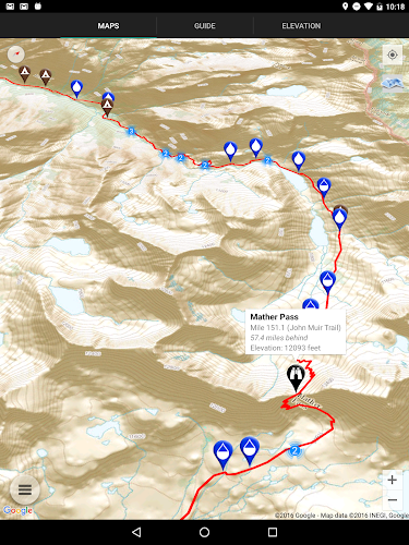
- Detailed maps with your GPS location
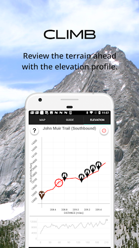
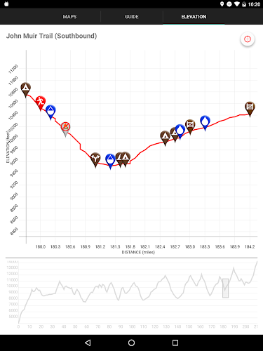
- Elevation profile view
- Custom route creator
- Multiple offline map choices
- Real-time comments from other hikers
- Send your current location to friends or family via text message or email
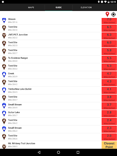
The guidebook lists every waypoint in order by distance along the trail and how far away you are from each waypoint. The guidebook also includes a detailed town guide for major resupply points, towns, and services along the JMT.
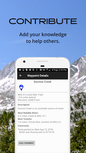
Waypoint details include:
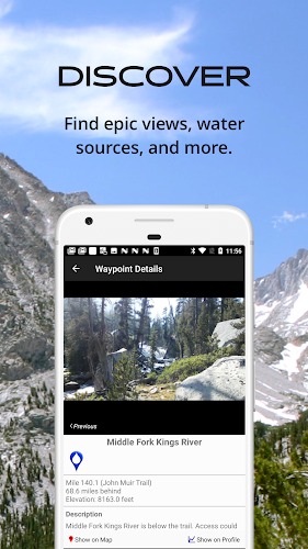
- Mileage point and elevation
- Photographs
- Distance to the next water source and tent site
- Comments section where you may post comments and read other hikers’ comments
Types of waypoints:
- Water sources (including the reliability of each water source)
- Detailed resupply and town information:
- post offices and other package services
- restaurants
- grocery stores and convenience stores
- gear shops and hardware stores
- laundromats
- lodging, public showers, public restrooms
- public libraries
- Tenting sites/camping sites
- Trail junctions
- Parking areas along the trail
- Picnic areas, campgrounds, ranger stations
- Roads, railroad tracks, power lines, fences, gates
- Natural landmarks (e.g. mountain passes)
- Privies/restrooms
- Views
Side Trails:
- Baxter Pass
- Bear Ridge (to Lake Edison)
- Bishop Pass
- Blayney Meadows
- Cascade Valley/Fish Valley Alternate
- Charlotte Lake
- Darwin Bench
- Devils Postpile
- Duck Pass
- Edison Lake (to ferry and to Vermilion Valley Resort)
- Evolution Crossing Alternate
- Florence Lake Ferry
- Half Dome
- Isberg Pass Alternate
- Kearsarge Pass (to Onion Valley)
- Rainbow Falls (at Reds Meadow)
- Mist Trail
- Mount Whitney Trail
- Muir Ranch
- Pacific Crest Trail Alternate
- Panorama Trail (to Glacier Peak Trailhead)
- Piute Pass
- Reds Meadow
- Sawmill Pass
- Shepherd Pass
- Sunrise Lakes/Tenaya Lake Trailhead
Resupply Info:
- Yosemite Village
- Tuolumne Meadows
- Lee Vining
- Red's Meadow
- Mammoth Lakes, CA
- Vermillion Valley Resort
- Muir Trail Ranch
- Bishop, CA
- Independence, CA
- Lone Pine, CA
About the John Muir Trail: The John Muir Trail, or JMT, is revered as one of the most pristine and beautiful trails in the world. The 210.5 mile trail makes its way through the heart of the Sierra Nevada Range in Central California. Much of the trail is above 10,000 feet elevation and is quite steep, making this a rather difficult trail. Most hikers hike the JMT southbound, beginning at Happy Isles in Yosemite National Park, and ending at the summit of the highest peak in the "lower 48" -- Mt. Whitney. It takes about 2-3 weeks to hike the entire trail (some hikers are faster, some are slower). Many hikers complete the entire trail in one go, and countless others enjoy hiking a few miles along the trail via the many remote side trails that branch off the JMT.
Also available:
Guthook's Pacific Crest Trail Guide
Guthook's Tahoe Rim Trail Guide
Mount Whitney Guide
How to install Guthook's John Muir Trail Guide APK for Android [menu]
Download Guthook's John Muir Trail Guide APK file from SameAPK.com, then follow these steps:
Update Phone Settings
- Go to your phone Settings page
- Tap Security or Applications (varies with device)
- Check the Unknown Sources box
- Confirm with OK
Go to Downloads
- Open Downloads on your device by going to My Files or Files
- Tap Install when prompted, the APK file you downloaded will be installed on your device.
How to install Guthook's John Muir Trail Guide APK on Windows 7/8/10 or MAC PC? [menu]
Download Guthook's John Muir Trail Guide APK file from SameAPK.com to your PC (ex: /Users/xxx/Downloads/), then follow these steps:
Using Emulator:
- Download And Install one Emulator Softwares (Ex: Bluestacks, GenyMotion, NoxPlayer)