
Table Of Contents

Latest update [menu]
6.0
--Improved performance/speed
--Improved location services
--Improved route creator tool
--Trail color option for colorblind/dark background
Description [menu]
The Mt. Whitney Guide is your free navigational guide for your hike up the Mt. Whitney Trail.
Mobile phone service is not available on all but a few feet of the Mt. Whitney Trail. But not to worry because the Mt. Whitney Guide app uses a combination of your phone's GPS, downloaded topo maps, and the Google Maps interface to accurately locate your position on the trail.
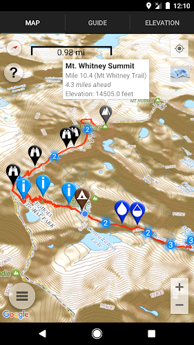
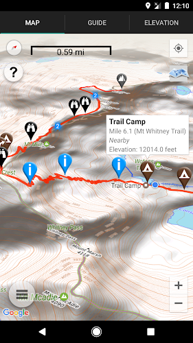
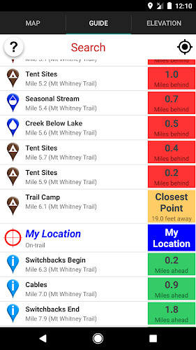
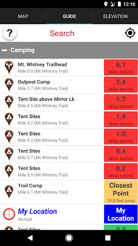
The Mt. Whitney Guide takes the guess work out of wondering how much farther you have to go, and more importantly, whether you are still on the trail. A bright red line indicates the location of the main trail on the map. Side trails are indicated in blue. Waypoints of interest to the hiker are plotted on the map. There are also markers on the map every mile or kilometer of the trail track.
The elevation profile shows trail distance vs elevation and plots your current location on the trail. Each waypoint is plotted on the profile. Each waypoints is clickable, opening to the waypoint's detail page.
The guidebook lists every waypoint in order by distance along the trail.
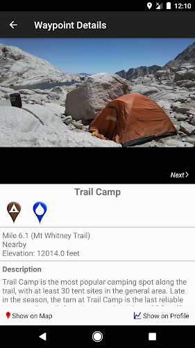
Each waypoint includes a detail page, providing further details about that particular waypoint. Details include the waypoint's mileage point and elevation, photographs of the waypoint, distance northbound and southbound to the next water source, a Trail Register where you may post comments and read other users' comments, and other details that will help you during your hike, and help you plan your hike.
Types of waypoints include:
-->Water sources (including reliability of each water source)
-->Campsites
-->Trail junctions
-->Information/landmarks
-->Views
About the Mt. Whitney Trail: The Mt. Whitney Trail is the most popular route to the top of Mt. Whitney, the highest point in the Lower 48 United States, at 14,505 feet (4,421 m). Located outside of Lone Pine, California, in the heart of the Sierra Nevada mountain range, the Mt. Whitney Trail connects to the 212-mile John Muir Trail, which in turn connects to the 2,660-mile Pacific Crest Trail. From the Mt. Whitney Trail trailhead to the top of Mt. Whitney is 10.4 miles (16.7 km) with an elevation gain of 6056 feet (1846 m). Many hike to the top and back in one day, while many others spend one or two nights on the trail.
Also available:
Guthook's PCT Guide (5-part guide to the Pacific Crest Trail)
Guthook's John Muir Trail Guide
Tahoe Rim Trail Hiker
How to install Mount Whitney Guide APK for Android [menu]
Download Mount Whitney Guide APK file (com.highsierraattitude.whitneyguide_6018_13134588.apk) from SameAPK.com, then follow these steps:
Update Phone Settings
- Go to your phone Settings page
- Tap Security or Applications (varies with device)
- Check the Unknown Sources box
- Confirm with OK
Go to Downloads
- Open Downloads on your device by going to My Files or Files
- Tap the APK file you downloaded (com.highsierraattitude.whitneyguide_6018_13134588.apk)
- Tap Install when prompted, the APK file you downloaded will be installed on your device.
How to install Mount Whitney Guide APK on Windows 7/8/10 or MAC PC? [menu]
Download Mount Whitney Guide APK file(com.highsierraattitude.whitneyguide_6018_13134588.apk) from SameAPK.com to your PC (ex: /Users/xxx/Downloads/(com.highsierraattitude.whitneyguide_6018_13134588.apk)), then follow these steps:
Using Emulator:
- Download And Install one Emulator Softwares (Ex: Bluestacks, GenyMotion, NoxPlayer)
- Simple install APK on PC by drag and drop file com.highsierraattitude.whitneyguide_6018_13134588.apk on Emulator screen
Mount Whitney Guide APK Pros & Cons [menu]
Pros
- This app is safe, it's not require high risk permissions
- Compatible with 32 bit device (most Emulator using 32bit arch CPU)
- Compatible with 64-bit device (some android device and current Bluestacks)
Cons
Everything is good.