Table Of Contents

Latest update [menu]
Optimize and reduce app size.
Fix bugs.
Description [menu]
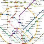
Singapore's MRT system is extending. By 2030, the MRT system will be more complex than you could image. It's good for all residents on our lovely island. But also will be a problem because we don't know how to travel the fastest when transfering stations.
Singapore MRT Map Route is designed to allows user to get the best route within a second. It will help you save a lot of time over years.
- View lastest Singapore MRT map
- Display the best route between two stations
- Automatically calculate estimated travel time
- Require no internet connection.
Updated to latest MRT system:
Downtown Line(Blue)
Bukit Panjang, Cashew, Hillview, Beauty World, King Albert Park, Sixth Avenue, Tan Kah Kee, Botanic Gardens, Stevens, Newton, Little India, Rochor, Bugis, Promenade, Bayfront, Downtown, Telok Ayer, Chinatown
Circle Line(Yellow)
Dhoby Ghaut, Bras Basah, Esplanade, Promenade, Nicoll Highway[C], Stadium, Mountbatten, Dakota, Paya Lebar, MacPherson, Tai Seng, Bartley, Serangoon, Lorong Chuan, Bishan, Marymount, Caldecott, Botanic Gardens, Farrer Road, Holland Village. Buona Vista, one-north, Kent Ridge, Haw Par Villa, Pasir Panjang, Labrador Park, Telok Blangah, HarbourFront
East West Line (Green)
Pasir Ris ,Tampines , Simei , Tanah Merah , Bedok , Kembangan , Eunos , Paya Lebar , Aljunied , Kallang , Lavender , Bugis , City Hall , Raffles Place , Tanjong Pagar , Outram Park , Tiong Bahru , Redhill , Queenstown , Commonwealth , Buona Vista , Dover ,Clementi , Jurong East , Chinese Garden , Lakeside , Boon Lay , Pioneer , Joo Koon, Expo,
Changi Airport
North South Line (Red)
Jurong East, Bukit Batok, Bukit Gombak, Choa Chu Kang, Yew Tee, Kranji, Marsiling, Woodlands, Admiralty, Sembawang, Canberra, Yishun, Khatib, Yio Chu Kang, Ang Mo Kio, Bishan, Braddell, Toa Payoh, Novena, Newton, Orchard, Somerset, Dhoby Ghaut, City Hall, Raffles Place, Marina Bay, Marina South Pier
North East Line (Purple)
HarbourFront, Outram Park, Chinatown, Clarke Quay, Dhoby Ghaut, Little India, Farrer Park, Boon Keng, Potong Pasir, Woodleigh, Serangoon, Kovan, Hougang, Buangkok, Sengkang, Punggol
How to install Singapore MRT Map Route 新加坡地铁 APK for Android [menu]
Download Singapore MRT Map Route 新加坡地铁 APK file (com.momostorm.sgmrt_16_23973973.zip) from SameAPK.com, then follow these steps:
Update Phone Settings
- Go to your phone Settings page
- Tap Security or Applications (varies with device)
- Check the Unknown Sources box
- Confirm with OK
Go to Downloads
- Open Downloads on your device by going to My Files or Files
- Download Split APKs Installer (SAI)
- Download and unzip file you already downloaded (com.momostorm.sgmrt_16_23973973.zip)
- Open Split APKs Installer and follow steps on this app.
- Tap Install when prompted, the APK file you downloaded will be installed on your device.
How to install Singapore MRT Map Route 新加坡地铁 APK on Windows 7/8/10 or MAC PC? [menu]
Download Singapore MRT Map Route 新加坡地铁 APK file(com.momostorm.sgmrt_16_23973973.zip) from SameAPK.com to your PC (ex: /Users/xxx/Downloads/(com.momostorm.sgmrt_16_23973973.zip)), then follow these steps:
Using Emulator:
- Download And Install one Emulator Softwares (Ex: Bluestacks, GenyMotion, NoxPlayer)
- Download and unzip file com.momostorm.sgmrt_16_23973973.zip.
- Using ADB or Split APKs Installer same as install for Android.
Singapore MRT Map Route 新加坡地铁 APK Pros & Cons [menu]
Pros
- This app is safe, it's not require high risk permissions
- Compatible with 32 bit device (most Emulator using 32bit arch CPU)
- Compatible with 64-bit device (some android device and current Bluestacks)
Cons
Everything is good.